Tag Archives: sea level rise

If all the ice on Earth melted, would your house be underwater?

Peter Lobner, updated 26 September 2023

Thanks to Lyncean member Mike Spaeth for sending me the article “What would the Earth look like if all the ice melted. The answer is terrifying,” which discusses the worst-case scenario of sea level rise after all the ice and snow currently locked away in glaciers, ice sheets and snowpacks has melted.

The bottom line is a sea level rise of 216 feet (65.8 m).

The article includes a link to a short, dramatic 2015 animated video by the same title, posted by Insider Science, which shows the global effects a 216 ft sea level rise.  You can watch this video on YouTube here: How Earth Would Look If All The Ice Melted

So, what about your neighborhood? You can explore a topographical map of the San Diego area here: https://en-us.topographic-map.com/map-n9tp/San-Diego/. Zoom in to determine the land elevations in specific neighborhoods and find the locations of the 216 ft elevation contour lines.

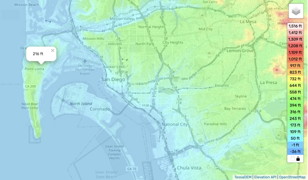
In the above map, everything in blue would be underwater after a 216 ft sea level rise, including all of Coronado, the Silver Strand, the downtown areas of San Diego, National City and Chula Vista, Lindberg Airport, Pacific Beach, Mission Valley and parts of Point Loma. Ironically, the submarine base near the tip of Point Loma would be underwater.

After you’ve found your house and the houses of families and friends in San Diego, you can expand your topographical search of the whole world.  All it takes is a bit of scrolling & zooming.  Some countries would be completely underwater.

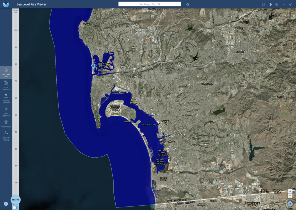
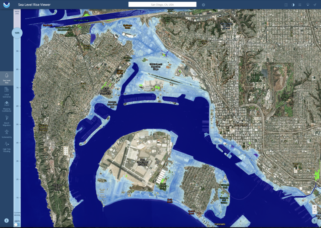
Thanks to Steve Masten for sending me the link to the Sea Level Rise Viewer developed by the National Oceanographic and Atmospheric Administration (NOAA).  With this visualization tool, you can see the gradual effects of sea level rise in coastal USA, up to a maximum rise of 10 feet (3 meters).  Below are example results for San Diego, CA.  

Current San Diego

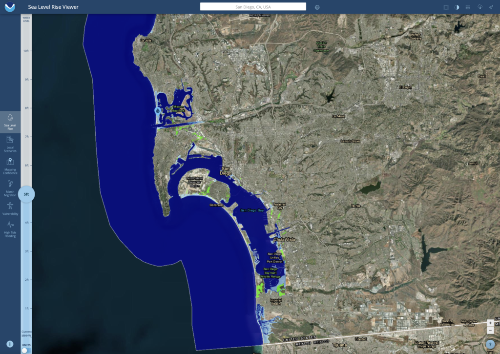
5 foot (1.5 meter) sea level rise 

Note the modest impacts in low-lying areas, particularly in South Bay.

10 foot (3 meter) sea level rise

There are significant flooded areas along the eastern bayfront from downtown San Diego to National City and Chula Vista. The San Diego Airport and Loma Portal are flooded. Coronado becomes two islands and the Silver Strand is underwater, opening the South Bay to the ocean.  Point Loma has become an island, and the strand of Mission Beach is underwater, opening Mission Bay to the ocean.

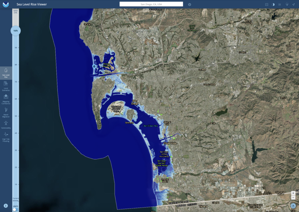
Here’s a closer look at the area around San Diego Bay after a 10 foot sea level rise.

For more information

Just What are Those U.S. Scientists Doing in the Antarctic and the Southern Ocean?

Peter Lobner

The National Academies Press (NAP) recently published the report, “A Strategic Vision for NSF Investments in Antarctic and Southern Ocean Research”, which you can download for free at the following link if you have established a MyNAP account:

http://www.nap.edu/catalog/21741/a-strategic-vision-for-nsf-investments-in-antarctic-and-southern-ocean-research

Print Source: NAP

NSF states that research on the Southern Ocean and the Antarctic ice sheets is becoming increasingly urgent not only for understanding the future of the region but also its interconnections with and impacts on many other parts of the globe. The research priorities for the next decade, as recommended by the Committee on the Development of a Strategic Vision for the U.S. Antarctic Program; Polar Research Board; Division on Earth and Life Studies; National Academies of Sciences, Engineering, and Medicine, are summarized below:

  • Core Program: Investigator-driven basic research across a broad range of disciplines
    • NSF gives the following rationale: “…it is impossible to predict where the next major breakthroughs or advances will happen. Thus to ensure that the nation is well positioned to take advantage of such breakthroughs, it is important to be engaged in all core areas of scientific research.”
      • NSF notes, “…discoveries are often made by single or small groups of PIs thinking outside the box, or with a crazy new idea, or even just making the first observations from a new place.”
    • Examples of basic research that have led to important findings include:
      • Ross Sea food chain is affected by a high abundance of predator species (whales, penguins and toothfish) all competing for the same limited resource: krill. Decline or recovery of one predator population can be seen in an inverse effect on the other predator populations.  This food chain response is not seen in other areas of the Antarctic ice shelf where predator populations are lower, allowing a larger krill population that adequately supports all predators.
      • Basic research into “curious” very-low frequency (VLF) radio emissions produced by lightning discharges led to a larger program (with a 21.2-km-long VLF antenna) and ultimately to a better understanding of the behavior of plasma in the magnetosphere.
  • Strategic, Large Research Initiatives –  selection criteria:
    • Primary filter: compelling science – research that has the potential for important, transformative steps forward in understanding and discovery
    • Subsequent filters: potential for societal impact; time-sensitive in nature; readiness / feasibility; and key area for U.S. and NSF leadership.
    • Additional factors: partnership potential; impact on program balance; potential to help bridge existing disciplinary divides
  • Strategic, Large Research Initiative – recommendations::
    • Priority I: The Changing Antarctic Ice Sheets Initiative to determine how fast and by how much will sea level rise?
      • A multidisciplinary initiative to understand why the Antarctic ice sheets is changing now and how they will change in the future.
      • Will use multiple records of past ice sheet change to understand rates and processes.
    • Priority II: How do Antarctic biota evolve and adapt to the changing environment?
      • Decoding the genomic (DNA) and transcriptomic (messenger RNA molecules) bases of biological adaptation and response across Antarctic organisms and ecosystems.
    • Priority III: How did the universe begin and what are the underlying physical laws that govern its evolution and ultimate fate?
      • A next-generation cosmic microwave background (CBM) program that builds on the current successful CMB program using telescopes at the South Pole and the high Atacama Plateau in Chile and possibly will add a new site in the Northern Hemisphere to allow observations of the full sky

You will find detailed descriptions of the Priority I to III strategic programs in the Strategic Vision report.