Peter Lobner
In Cambodia, remote sensing is proving to be of great value for looking beneath a thick jungle canopy and detecting signs of ancient civilizations, including temples and other structures, villages, roads, and hydraulic engineering systems for water management. Building on a long history of archaeological research in the region, the Cambodian Archaeological Lidar Initiative (CALI) has become a leader in applying lidar remote sensing technology for this purpose. You’ll find the CALI website at the following link:
Areas in Cambodia surveyed using lidar in 2012 and 2015 are shown in the following map.
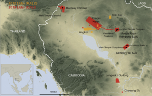 Source: Cambodian Archaeological LIDAR Initiative (CALI)
CALI describes its objectives as follows:
“Using innovative airborne laser scanning (‘lidar’) technology, CALI will uncover, map and compare archaeological landscapes around all the major temple complexes of Cambodia, with a view to understanding what role these complex and vulnerable water management schemes played in the growth and decline of early civilizations in SE Asia. CALI will evaluate the hypothesis that the Khmer civilization, in a bid to overcome the inherent constraints of a monsoon environment, became locked into rigid and inflexible traditions of urban development and large-scale hydraulic engineering that constrained their ability to adapt to rapidly-changing social, political and environmental circumstances.”
Lidar is a surveying technique that creates a 3-dimensional map of a surface by measuring the distance to a target by illuminating the target with laser light. A 3-D map is created by measuring the distances to a very large number of different targets and then processing the data to filter out unwanted reflections (i.e., reflections from vegetation) and build a “3-D point cloud” image of the surface. In essence, lidar removes the surface vegetation, as shown in the following figure, and produces a map with a much clearer view of surface features and topography than would be available from conventional photographic surveys.
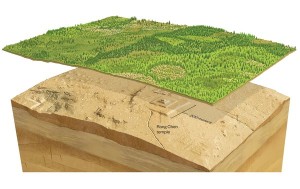 Source: Cambodian Archaeological LIDAR Initiative
CALI uses a Leica ALS70 lidar instrument. You’ll find the product specifications for the Leica ALS70 at the following link:
http://w3.leica-geosystems.com/downloads123/zz/airborne/ALS70/brochures/Leica_ALS70_6P_BRO_en.pdf
CALI conducts its surveys from a helicopter with GPS and additional avionics to help manage navigation on the survey flights and provide helicopter geospatial coordinates to the lidar. The helicopter also is equipped with downward-looking and forward-looking cameras to provide visual photographic references for the lidar maps.
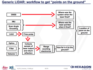
Basic workflow in a lidar instrument is shown in the following diagram.
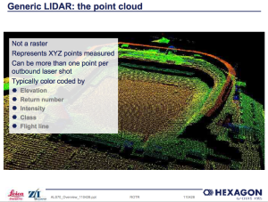
An example of the resulting point cloud image produced by a lidar is shown below.
Here are two views of a site named Choeung Ek; the first is an optical photograph and the second is a lidar view that removes most of the vegetation. I think you’ll agree that structures appear much more clearly in the lidar image.
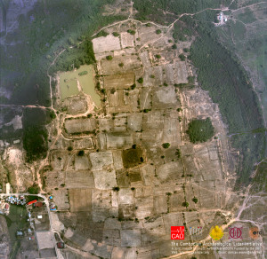 Source: Cambodian Archaeological LIDAR Initiative
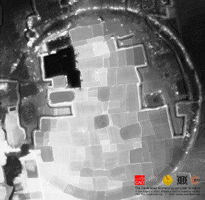 Source: Cambodian Archaeological LIDAR Initiative
An example of a lidar image for a larger site is shown in the following map of the central monuments of the well-researched and mapped site named Sambor Prei Kuk. CALI reported:
“The lidar data adds a whole new dimension though, showing a quite complex system of moats, waterways and other features that had not been mapped in detail before. This is just the central few sq km of the Sambor Prei Kuk data; we actually acquired about 200 sq km over the site and its environs.”
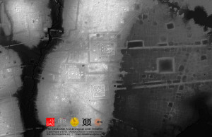 Source: Cambodian Archaeological LIDAR Initiative
For more information on the lidar archaeological surveys in Cambodia, please refer to the following recent articles:
See the 18 July 2016 article by Annalee Newitz entitled, “How archaeologists found the lost medieval megacity of Angkor,” on the arsTECHNICA website at the following link:
On the Smithsonian magazine website, see the April 2016 article entitled, “The Lost City of Cambodia,” at the following link:
http://www.smithsonianmag.com/history/lost-city-cambodia-180958508/?no-ist
Also on the Smithsonian magazine website, see the 14 June 2016 article by Jason Daley entitled, “Laser Scans Reveal Massive Khmer Cities Hidden in the Cambodian Jungle,” at the following link:
